


このページは過去に開催されたイベントの情報です。
This page is information on events held in the past.
DAY REPORT LINK: ET8 [JP] [EN] | ET7 [JP] [EN] | ET6 [JP] [EN] | ET5 [JP] [EN] | ET4 [JP] [EN] | ET3 [JP] [EN] | ET2 [JP] [EN] | ET1 [JP] [EN] |
SAYHAN OVOO⇒BAYANHONGOR
S:177.71km L:33.06km S:258.54km L:17.89km TOTAL:487.20km
S:177.71km L:199.31km TOTAL:377.02km【SM_class】
ETAP3 REPORT
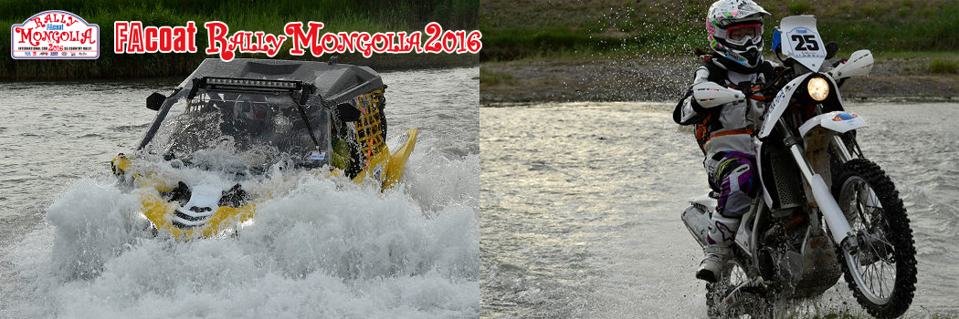
Today the season seems to have moved on somewhat with the heat waves from yesterday ending and a high-pressure zone from Siberia starting to appear. The SS1 start point is prepared at a river crossing and the rally vehicles one by one took up the challenge of getting across the river while watched by rally officials as well as French and Italian tourists. One accident happened where Higashi’s rally bike was washed away but almost all drivers made it across safely and headed west. In the opening part of SS2, rally rider Maekawa was injured in a crash and competitor Shinohara also crashed in the latter half. Both of them had X-rays taken, got medical treatment, and had to leave the rally.
Rider Ouchida had electrical trouble causing him to stop along the route and lose a lot of time but finally got back in competition. After the CP (check point) competitors next encountered a piste along a high cliff and a route with difficult navigation but finally all competitors reached the goal. Tonight’s accommodations are a hotel. The mountain road from ETAP5 onward has a high amount of rainfall so that route is scheduled to be checked.
ROUTE INFORMATION
「Heading to the western region along the road through the valley」
SS-1 starts right from the bivouac. Moreover we also cross a river that lies right beyond the start gate so most of the gallery watchers in the bivouac area no doubt gave us a thunderous burst of applause when they saw us. Finally we find ourselves running through the mountains and if we can just get through an area where navigation is a little difficult we will reach the high-speed piste. The short SS-1 ends just before a paved road. The SM class heads toward Bayanhongor from there via this paved road.
The SS-2 cars then head south on the high-speed piste, we make a CAP (compass heading) change at the town there and get back on the highway.
The piste on the left end that we took gradually separates from the highway and we eventually reach a small village. The left route enters the mountains from here. We leave the valley but the cliffs are high around here. We move ahead very slowly and cautiously. After passing through a number of valleys we emerge into an area where the grounds widens into a surface covered by volcanic rock. These are jagged, pointy rocks so we drive along carefully spending a lot of time to pass through the area without getting flat tires. After leaving the volcanic rock area, we realize we are more than 2,000 meters above sea level. We finish the SS and refuel at a gas station along the paved road and then head along this paved liason to the bivouac.
Results
http://www.sser.org/hpp/2016_rm2016/res-pdf/RM2016_ETAP-3.pdf
Photo
